Table of Contents
- What is a bathymetric study in maritime structures?
- Physical oceanography and coastal modeling
- Hydrodynamics and uncertainty reduction in maritime design
- Sediment dynamics and stability of maritime structures
- Applications in ports, offshore, and underwater structures
- Integrated engineering in practice: the BUZCA approach
- Technological trends in bathymetry and coastal modeling
- Conclusions
- References
- Frequently Asked Questions (FAQs)
- At what stage of a project is a bathymetric study performed?
- What is the difference between bathymetry and physical oceanography?
- Why is hydrodynamic modeling important in ports?
- How does sediment transport influence a maritime structure?
- What happens if bathymetry is not updated?
- What are the common mistakes in coastal engineering?
Every maritime structure, whether a port, breakwater, offshore terminal, navigation channel, or marine energy infrastructure, depends on one fundamental condition: accurately understanding the behavior of the marine environment before intervening in it.
The ocean floor, currents, waves, and sediment dynamics are not independent variables. They form an interconnected physical system that determines the stability, durability, and feasibility of any coastal structure.
In this context, bathymetry and coastal modeling are not auxiliary disciplines. They are the technical foundation upon which modern maritime engineering is built.
What is a bathymetric study in maritime structures?
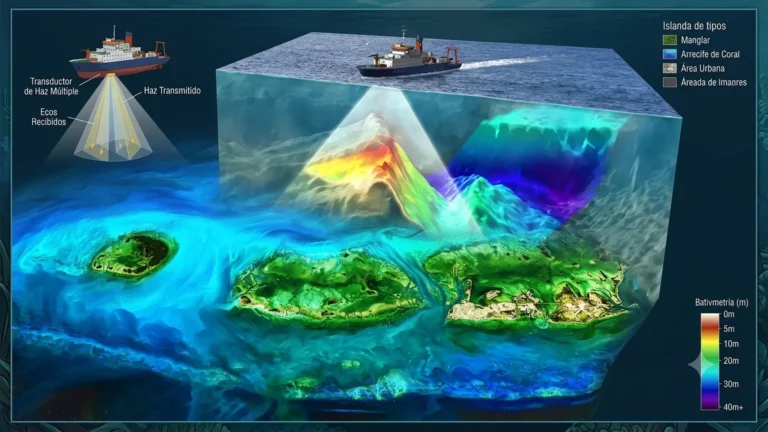
Bathymetry is the measurement and representation of the seabed relief. Its objective is to obtain a digital model of the underwater terrain that allows understanding the geometry of the seabed before any design or intervention.
In modern maritime engineering, this process relies on technologies such as multibeam echosounders, high-precision GNSS systems, and dynamic positioning platforms, which make it possible to generate high-density point clouds.
The result is not just a map. It is a geospatial model of the underwater terrain, used as the basis for calculations involving:
- Dredging volumes.
- Foundation design.
- Structural stability.
- Navigation route assessment.
Without this input, any maritime design operates with structural uncertainty from its origin.
Physical oceanography and coastal modeling
The behavior of the sea as a dynamic system
Physical oceanography studies the processes that govern water movement in coastal environments: tides, currents, wind, and waves. Coastal modeling translates these phenomena into numerical simulations that make it possible to analyze operational scenarios under different environmental conditions.
Models such as Delft3D, MIKE 21, or SWAN make it possible to represent:
- Current distribution.
- Wave propagation.
- Flow–structure interaction.
- Morphodynamic changes along the coast.
This type of modeling does not seek to predict the ocean with absolute accuracy, but rather to reduce uncertainty in hydrodynamic behavior during engineering design.
Hydrodynamics and uncertainty reduction in maritime design
Coastal hydrodynamics connects the energy of the marine system with the response of the physical environment.
In engineering, its main function is to evaluate how water interacts with structures such as:
- Piers
- Breakwaters
- Offshore piles
- Port terminals
One of the critical aspects is the transfer of wave energy to the seabed, which can generate phenomena such as local erosion, scour, or structural instability.
Hydrodynamic modeling makes it possible to anticipate these effects before construction, becoming a key tool for risk management in maritime infrastructure.
Sediment dynamics and stability of maritime structures
Sediment transport constitutes one of the most influential geomorphological processes affecting the stability and service life of any maritime infrastructure. Contrary to what might be assumed, the seabed does not represent an inert surface, but rather a highly dynamic system whose morphology continuously evolves in response to the energy exchange between waves, currents, tides, and the characteristics of the sediment itself.
Each variation in the hydrodynamic regime modifies the balance between the forces that mobilize particles and those that keep them deposited on the seabed, generating continuous processes of erosion and accumulation.
The energy transmitted by waves generates shear stresses on the seabed capable of suspending particles of different grain sizes, while longshore currents induced by the oblique incidence of waves produce the well-known littoral drift responsible for the continuous displacement of sand along coastlines.
During extreme events such as storms, hurricanes, or storm surges, these hydrodynamic conditions reach levels far beyond those considered under normal operating conditions, causing significant bathymetric changes over relatively short periods.
Added to this natural behavior is the interaction between maritime structures and water flow, since dikes, breakwaters, piles, groins, or offshore platforms locally alter current velocities and modify natural circulation patterns, generating preferential zones of both deposition and erosion.
Applications in ports, offshore, and underwater structures
The integration of bathymetric studies, sedimentological analysis, and coastal modeling has direct applications in the design, construction, and operation of maritime infrastructure. These tools make it possible to understand seabed dynamics and anticipate changes that may affect the stability, safety, and service life of structures.
In ports and maritime terminals, evaluating erosion, sedimentation, and sediment transport processes is essential for maintaining the operational draft of navigation channels and minimizing dredging requirements. The migration of sandbanks and the progressive accumulation of sediments can significantly alter navigability and the operational efficiency of port facilities.
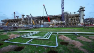
In offshore projects such as energy platforms, LNG terminals, or offshore wind farms, hydrodynamic and sedimentological analysis makes it possible to identify areas susceptible to localized scour around piles, foundations, caissons, or subsea pipelines. This phenomenon occurs when flow acceleration increases shear stress on the seabed, generating excavations that may compromise load-bearing capacity and structural stability.
Likewise, in the installation of subsea cables and pipelines, seabed characterization makes it possible to predict exposure, burial, or displacement processes associated with sediment transport and coastal dynamics. Inadequate assessment can result in higher maintenance costs, operational failures, or environmental risks.
Coastal modeling also plays a key role in shoreline protection and beach nourishment projects, where it is essential to predict the morphological evolution of the coastline under different wave, current, and extreme event scenarios.
Therefore, the combined analysis of bathymetry, hydrodynamics, and sedimentology should not be considered merely a complementary study, but rather a strategic tool for optimizing the hydraulic, geotechnical, and structural design of modern maritime structures.
The following video examines how bathymetry and coastal modeling optimize design and operational safety in ports, offshore facilities, and subsea structures.
Integrated engineering in practice: the BUZCA approach
The evolution of maritime engineering has led to an increasingly integrated model, where bathymetry, oceanography, environmental modeling, and structural design are no longer developed separately.
In this context, specialized organizations such as BUZCAS.A represent this transition toward integrated maritime engineering.
With more than 50 years of experience in industrial diving services, underwater engineering, oceanographic studies, and environmental modeling, BUZCA has evolved toward a multidisciplinary approach that integrates field data, technical analysis, and solution design for maritime and river infrastructure across Latin America.
This type of integration allows information obtained in the field to go beyond a technical report and become direct input for the design, construction, and maintenance of offshore and coastal infrastructure.
Technological trends in bathymetry and coastal modeling
Maritime engineering is entering a phase of advanced digitalization driven by new technologies:
- Bathymetry using autonomous surface vehicles (USV).
- High-resolution multibeam sensors.
- Integration with artificial intelligence.
- Digital twins of coastal environments.
- Real-time hydrodynamic modeling.
- Use of airborne bathymetric LiDAR.
These technologies are significantly reducing survey times and increasing the accuracy of engineering models.
Conclusions
Bathymetry and coastal modeling constitute the technical foundation of any maritime structure, as they make it possible to evaluate the safety, feasibility, and sustainability of projects from the earliest design stages.
In sectors such as ports, offshore energy, subsea cables, and coastal protection, these tools facilitate understanding of seabed dynamics, foundation stability, and sedimentary evolution, reducing operational risks and maintenance costs.
Understanding the morphology and behavior of the marine environment is not merely a preliminary project phase, but the foundation supporting the hydraulic, geotechnical, and structural decisions of modern maritime engineering.
References
- van Rijn, L. C. J., Davies, A. G., van de Graaff, J., & Ribberink, J. S. (2001). SEDMOC: Sediment transport modelling in marine coastal environments. Acqua Publications.
- Losada, Í. J., Medina, R., Losada, M. Á., & Vidal, C. (1995). Hydrodynamic and sediment transport models. Ingeniería del Agua, 2(5), 99–108. https://doi.org/10.4995/ia.1995.2667
- Klonaris, G., Memos, C. D., Drønen, N. K., & Deigaard, R. (2017). Boussinesq-type modeling of sediment transport and coastal morphology. Coastal Engineering Journal, 59(1). https://doi.org/10.1142/S0578563417500073
- Schoellhamer, D. H., Ganju, N. K., Mineart, P. R., & Lionberger, M. A. (2008). Sensitivity and spin-up times of cohesive sediment transport models used to simulate bathymetric change. Proceedings in Marine Science, 9, 463–475. https://doi.org/10.1016/S1568-2692(08)80033-2
Frequently Asked Questions (FAQs)
At what stage of a project is a bathymetric study performed?
During the conceptual and basic engineering phase, before structural design.
What is the difference between bathymetry and physical oceanography?
Bathymetry describes the seabed; oceanography studies the dynamic behavior of water.
Why is hydrodynamic modeling important in ports?
It allows evaluation of waves, currents, and sedimentation that affect operability.
How does sediment transport influence a maritime structure?
It can generate erosion or accumulation that compromises structural stability.
What happens if bathymetry is not updated?
The design may rely on outdated information, increasing operational risk.
What are the common mistakes in coastal engineering?
One of the most frequent mistakes in maritime projects is designing with outdated or low-resolution bathymetric information. Another critical error is separating environmental modeling from structural design, generating inconsistencies between the expected and actual behavior of the marine system. It is also common to underestimate sediment transport, leading to early maintenance problems in navigation channels and port structures.